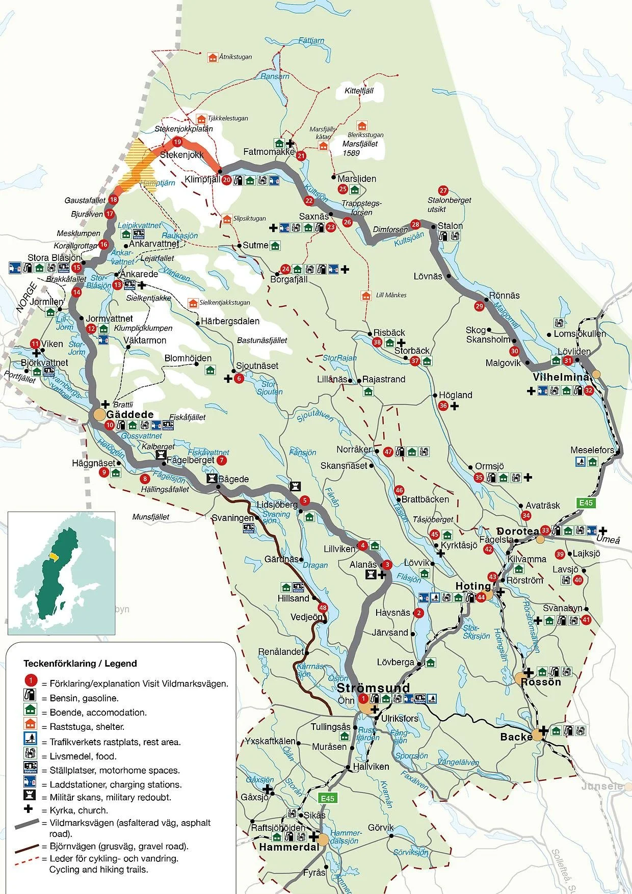
Wilderness road in the North of Sweden
Sweden’s breathtaking and scenic Wilderness Road proudly holds the title of the country’s highest paved road, reaching an impressive elevation of 867 metres above sea level at its highest point. This remarkable 500-kilometre circular route begins in the picturesque town of Strömsund, nestled in northern Jämtland, and winds its way via the small village of Gäddede to the charming town of Vilhelmina in southern Lapland. Along the way, it conveniently connects with the E45 highway through Dorotea, making it accessible for many travelers. One of the most iconic and stunning parts of this drive traverses the breathtaking Stekenjokk Plateau, a protected Sámi heritage landscape where majestic reindeer graze freely and rare bird species flourish in their natural habitat.
Good to keep in mind: This particular section of the road is only open for exploration from 6 June to 15 October each year, owing to the significant and vast amounts of snow that blanket the area during the winter months.
Where to start and getting around
It doesn’t really matter where you start since the route is a circle, so begin at the point that makes the most sense for your specific trip. Strömsund is the southernmost point from where you can start traveling north through Sweden. Gäddede is the furthest point to the west, so if you’re coming from Norway, as I did, it makes more practical sense to start your journey there. Without a doubt, having a vehicle is essential to get around because there is no public transportation available along this route. However, if you search online, you might find some organized bus trips that cover parts of it.
The roads themselves are narrow and winding, but generally in good condition—especially in and around the larger villages where the roads are better maintained. If you're traveling in the late or very early season, be prepared for winter-like conditions. Keep in mind that these roads are only fully open during summer and autumn, so plan accordingly for your safety and convenience. Gas is not a great problem since you will pass by several villages and small cities.
Ackommodation
There are several places to stay for the night along the road, many small cabins to be rented and/or camping sites. During peak season check online to make sure there is a room available. If youre going by camper van you can pretty much stop wherever you like, a public parking spot or a flat enough space you find along the road. Just make sure not to park on private land of course. If you have a tent you are aloved to camp for the night under the “Freedom to roam act” as long as you use common sense and do not camp too close to houses or on farmed land. For a english version of the act please visit this website.
I used a car and a tent, and there are many great places to camp even if the ground is very uneven at places.
Food and Water
Food will be avalible along the route and also smaller grocery stores where you can buy what you need for the comming day(s). Water can also be found in numerous places and the water in nature is more than drinkable in Sweden as long as it moving. Avoid smaller lakes and try to find a stream when outside urban areas. Every swedish people dring directly from nature in Sweden and if you just remember 1. outside. of urban areas and 2. streaming you will be safe.
Highlights
I have to admit i did not travel the full circle, both due to a recommendation from a friend and me knowing the area. The best part in my opinion is the east part of the circle, south of Gäddede to Stekenjokken plateau.
Hällingsåfallet
Hällingsåfallet is one of the country's highest waterfalls and Sweden's longest canyon. The waterfall cascades down into a ravine over 40 meters deep and then squeezes out into a narrow canyon. After 800 meters, the crack widens and the water spreads out into a calmer riverbed that stretches three kilometers to its outflow in Lake Hetögeln. 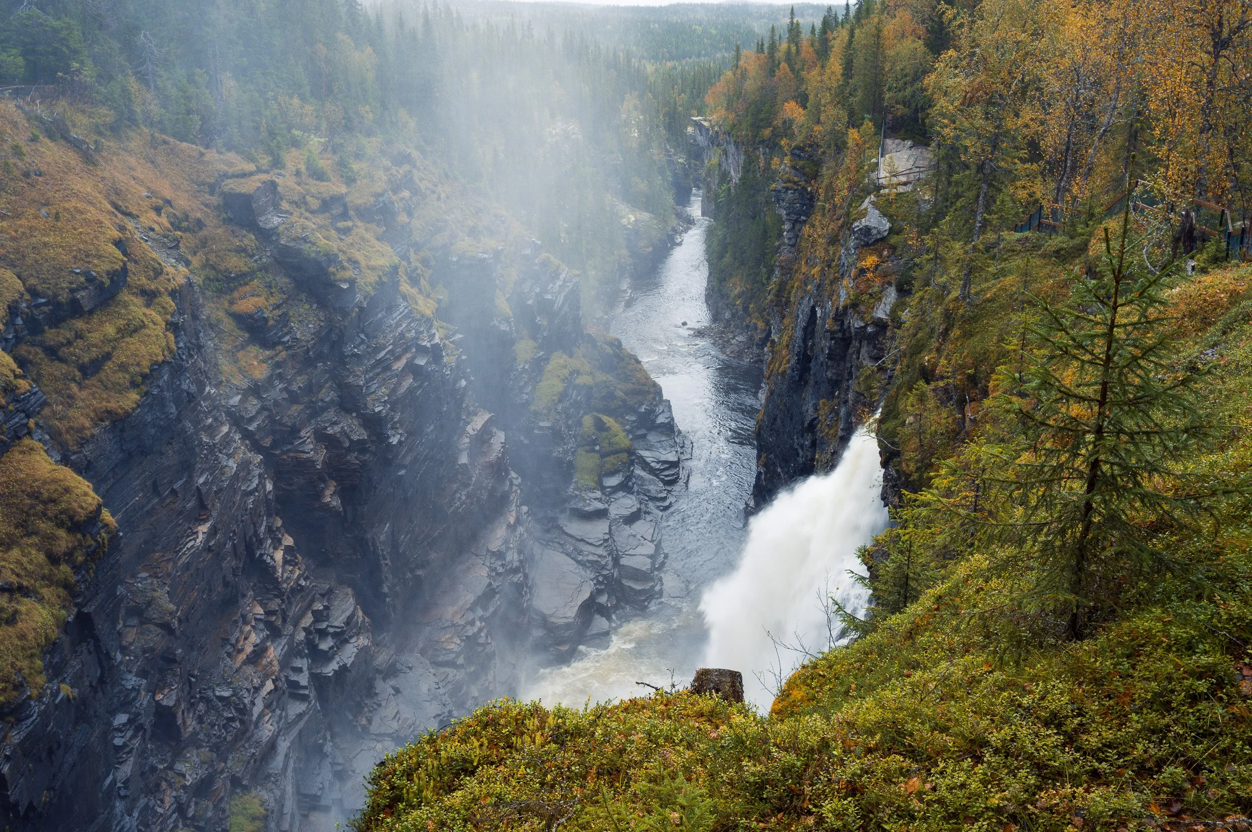
Hällingsåfallet
Brakkåfallet
Brakkåfallet actually consists of a lower and an upper waterfall. Although many people are content with the beautiful lower waterfall, which is also great for swimming thanks to its flat rocks, the more adventurous can continue the path up to see the upper waterfall as well.Bjurälvens naturreservat
Bjurälven is Scandinavia's largest karst landscape – a unique nature reserve. Bjurälven is also called "the invisible river" because it flows underground in parts. Along the riverbed, the water has formed gullies, siphons, sinkholes, funnels and caves, and along the path leading to the river there is a unique flora.Gaustafallet
Gaustafallet is one of Sweden's most spectacular waterfalls when all the meltwater rushes down the falls during early summer. If you want to experience the falls with its full power and deafening sound, this is the time to go. Its also known from Astrid Lindgrens “Ronja Rövardotter” or in english “Ronja the robber's daughter”.
Stekenjokken
The stretch of the Wilderness Road over Stekenjokk is one of the few places in Sweden where the road goes straight through the bare mountain and gives you the opportunity to hike on wheels in a Sami cultural landscape. Its this part that closes during winter. The 16-kilometer stretch over the bare mountain is a fantastic sight. Located at an altitude of 900 meters with a snow depth of almost three meters in the spring and where the embankments after plowing can be more than six meters high.
There are many many more places to visit and google it and pick the ones that interest you the most.